|
Looking for... |
Search with... |
. |
| "100 Blocks" - in other words, how far north or
south is such and such a street? |
Name of the street, or a direction and number |
Example: You want to know how far north Capitol Ave is, enter CAPITOL, See result
Or another Example: You want to know what street is 4300 South, enter S4, See result - you will get a list of all
streets that are between S4000 and S4900.
|
| Bike/Hiking Trails |
TRL |
Use TRL to get a list of locations where the Oak Leaf Bike Trail crosses streets or some other landmark. You can also search using
intersections. Examples:
Common Places: TRL, TRL COLD, TRL BENCH
or an intersection: TRL/COLD, TRL/DREX, etc,
See an example of a common place entry
See an example of a intersection entry .
|
Branches |
BRANCH |
NOTE: there are no addresses associated with these locations. You MUST
ask the caller for his/her specific location! They could be in the Courthouse, Safety Building, or even on county Grounds! |
| Cell Towers |
CELL |
Using just "Cell" is going to give you a very long list. If you want to search for a specific cell phone company tower use (you'll still get a list, but not as long):
CELL TOWER A (FOR AT&T sites)
CELL TOWER S (FOR SPRINT AND NEXTEL sites)
CELL TOWER U (FOR US CELLULAR sites)
CELL TOWER T (FOR TMOBILE sites)
CELL TOWER V (FOR VERIZON sites)
CELL TOWER C (FOR CRICKET sites)
Read more about E911 Basics |
| Cardinal Stritch Univ |
CSU |
. |
| Department of Motor Vehicles |
DMV |
. |
| Exits |
EXIT |
DO NOT use a space, example: EXIT310
NOTE: Enter exits just like you enter the Mile Markers, no spaces. Example: MM3 or EXIT6. |
| Fire Departments |
FIRE |
Or Fire Station |
| "Gates" at Miller Park & State Fair |
GATE |
. |
| Heart Defibs |
AED
Example: AED CH (For those installed in the Courthouse)
Or AED SB (in the Safety Bulding). There are also locations at various businesses. Enter AED and
then the first few letters of the business to narrow it down, or use just AED to search the entire list. |
Otherwise Known as "Automated External Defibrillator"
NOTE: THESE ARE NO LONGER BEING ENTERED IN CAD HOWEVER SOME ARE STILL AVAILABLE. BE ADVISED THEY ARE NEITHER UPDATED OR
MAINTAINED AT THIS TIME!
|
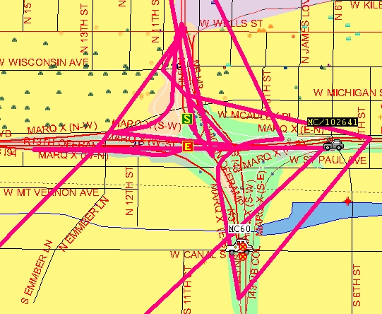
| Interchanges |
Use the freeway designation and then the name of the Interchange - this will provide you with all options for that interchange |
Examples: US45 N/GRAN, STH145 N/GRAN, I43 N/MARQ, etc., etc. For more info, go here
See an example of an interchange common place entry
See examples of an interchange using an intersection
|
| Marquette Univ |
MU |
. |
| Mental Health Complex |
MHC |
Example, enter MHC 4 to find all wards that start with a "4"
See an example of a ward here
|
| Mile Markers |
MM |
No spaces; example: MM3
Be aware, there may be two separate, different locations for any given exit number; for instance in this example - EXIT 40/MM40 - can be on US45 or US41, so make sure you ask the caller follow-up questions to determine exactly where they are! Follow this link for details.
|
| Milwaukee Police Districts |
MILW PD |
or to get really specific - MILW PD DIST |
| Milwaukee... |
MILW |
Any location name that begins with "Milwaukee" is abbreviated in CAD. Use only MILW for searches on these locations.
Example: Milwaukee Art Museum should be searched for using MILW ART - if you type in the entire word "Milwaukee" you will get
no results. |
| Municipalities |
City of...(plus first three or four letters of city or village name) |
Examples: CITY OF BAY, CITY OF GREEN. Generally used for "Field Inspections" - be aware, these are just general locations and do not indicate where your squad actually is. Even though some are villages, all start with City, for consistencies sake. |
| Oil Dry Locations |
OIL |
View the map |
| Overpasses |
OP |
See an example here |
| Park & Ride Lots |
Enter the first word (see exception) of the park and ride, followed by a P |
Example: HOLT P, HALE P, etc. Exception: RYAN ROAD P |
| Pedestrian Overpasses |
OP |
See an example here |
| Police Agencies |
City name, plus PD |
Examples: WHI BAY PD, MILW PD, GREEN PD, etc |
| Radio Sites |
RS |
. |
| Stop Lights |
TS |
In the "address" field, it should indicate if it's a STATE or COUNTY light. |
| Crash Inv Sites |
CRASH |
. |
| Security Checkpoints in CH Complex |
POST |
At one point these locations were referred to as Post1, Post2, etc. That's why they are entered this way.
Do a Shift-F8 to get to the 2nd page; there are several Post Offices listed first. |
| Univ of Wisconsin - Milwaukee |
UWM |
. |
| Viaducts |
VIA |
Example |
| Walmarts/Walgreens |
WALG or WALM |
There's quite a list of these but by no means are all Walmarts and Walgreens in CAD ! |

 Reminders - ATM and other Procedures
 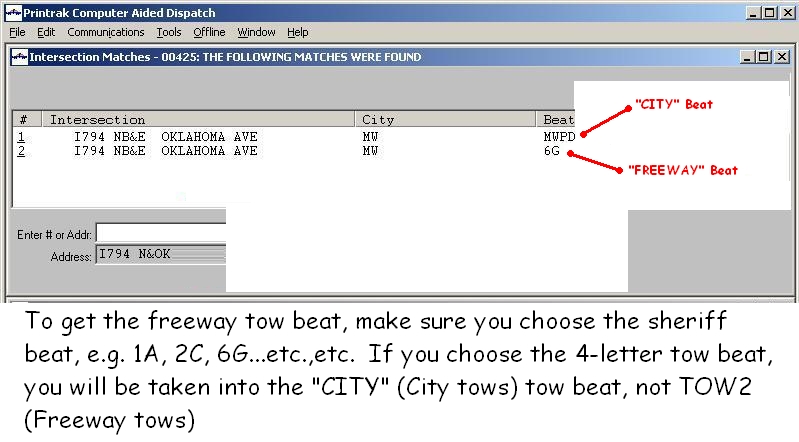 All locations in the county have a tow beat assigned to them. In order for the Tow Rotation
to work properly, the correct beat has to be chosen during address verification. Any given address
in the county should automatically be in the correct beat, however, on the freeway system
it's possible to have multiple choices. CAD is designed to give us these multiple choices, however
care must be taken to choose the correct beat so the tow rotation will provide you with
the correct tow vendor.
All locations in the county have a tow beat assigned to them. In order for the Tow Rotation
to work properly, the correct beat has to be chosen during address verification. Any given address
in the county should automatically be in the correct beat, however, on the freeway system
it's possible to have multiple choices. CAD is designed to give us these multiple choices, however
care must be taken to choose the correct beat so the tow rotation will provide you with
the correct tow vendor. 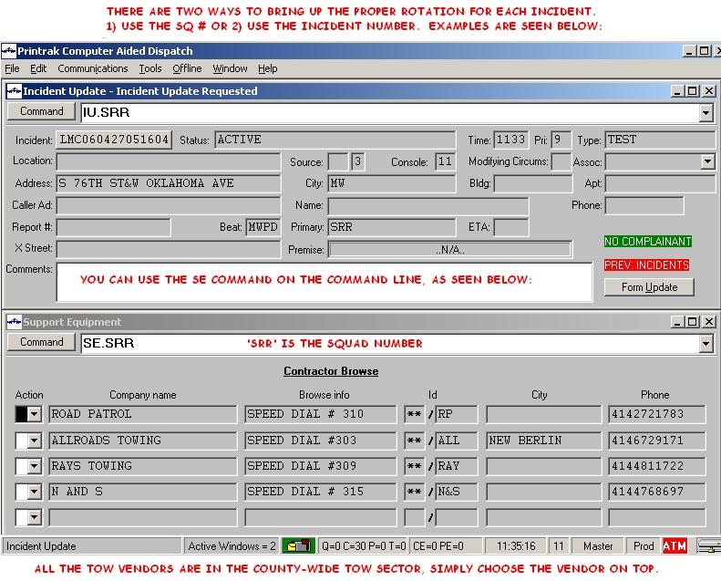
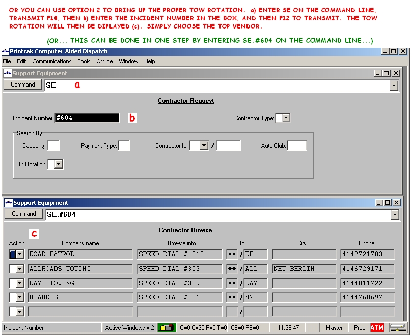


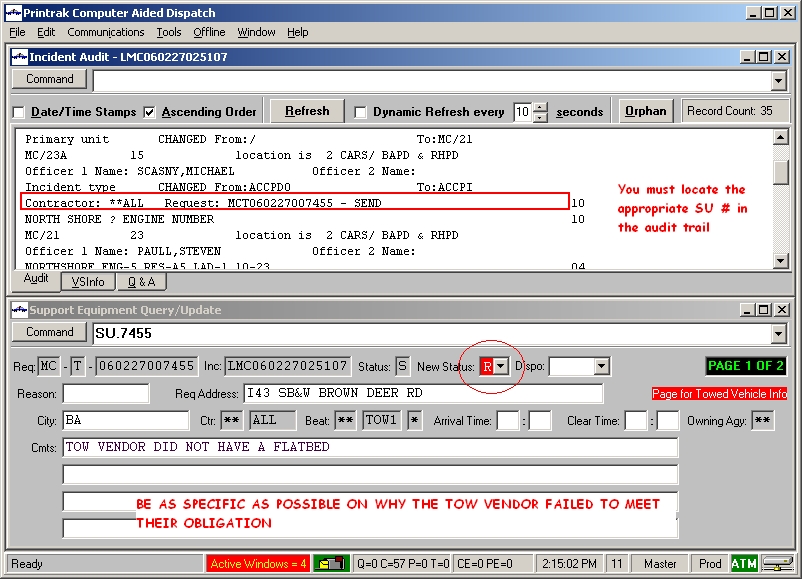 How to add comments into the SU form for Cancelled and Retracted Tows.
Read more about "C and R"
How to add comments into the SU form for Cancelled and Retracted Tows.
Read more about "C and R" 


